The India Meteorological Department (IMD) has issued a comprehensive weather warning of Thunderstorms and Hailstorms for the period of March 18 to March 21, 2026. A powerful fresh Western Disturbance is currently moving across the Western Himalayan Region. Consequently, residents across Northwest, Central, and East India should prepare for a volatile spell of scattered thunderstorms and lightning. This system will likely bring much-needed relief from early March heat, but it also carries the risk of significant agricultural disruption.
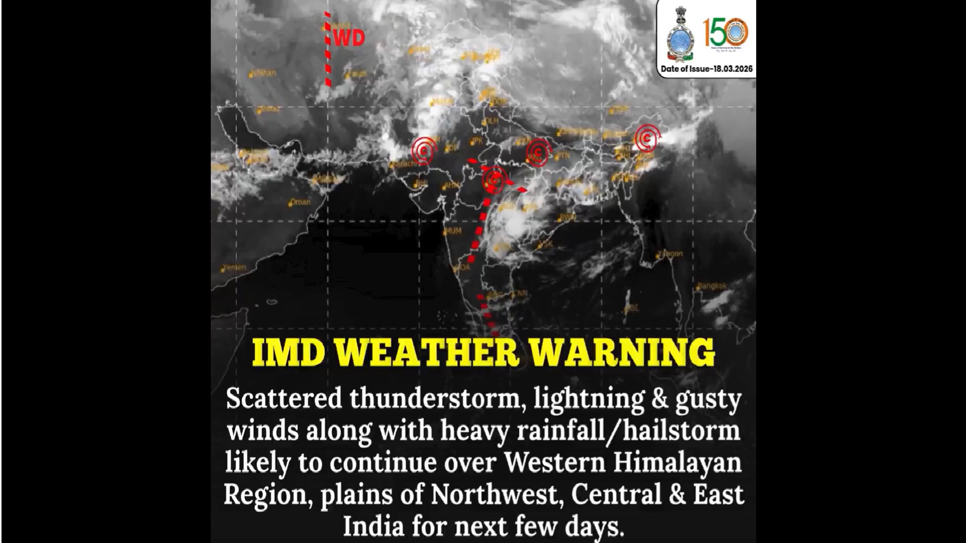
⚠️ IMD Weather Warning !
Scattered thunderstorms ⛈️, lightning ⚡, gusty winds 💨, and heavy rainfall/hailstorms 🌧️ expected across the Western Himalayan Region and plains of Northwest, Central & East India over the next few days.
Stay alert, stay safe, and take necessary… pic.twitter.com/ptslyq0oaR
— India Meteorological Department (@Indiametdept) March 18, 2026
According to the latest IMD bulletin, the most intense activity will occur on March 19 and 20. During this time, gusty winds reaching speeds of 40–50 kmph will sweep through the plains. Furthermore, isolated hailstorms are very likely in states like Punjab, Haryana, and Rajasthan. Travelers heading to the mountains should exercise extreme caution as visibility may drop sharply during heavy downpours.
Snowfall and Heavy Rain in the Mountains
The high-altitude reaches of Jammu & Kashmir, Ladakh, and Himachal Pradesh are currently witnessing a prolonged wintry spell. The IMD predicts heavy rainfall and snowfall specifically for Himachal Pradesh and Uttarakhand on March 19 and 20. Additionally, thundersqualls with wind speeds gusting up to 70 kmph might hit isolated pockets of Uttarakhand.
Lower altitudes and valley regions will likely see moderate rainfall accompanied by frequent lightning strikes. Moreover, the drop in temperature will be significant. Forecasts suggest a dip of 5–7°C in maximum temperatures across Northwest India over the next three days. This cooling effect will temporarily halt the onset of summer heatwaves that typically begin in late March.
Central and East India Brace for Volatile Weather
The impact of this weather system extends far beyond the northern mountains. Central India, particularly Chhattisgarh and Vidarbha, is under a hailstorm watch for March 18 and 19. Meanwhile, East India will experience its own set of challenges. States like West Bengal, Odisha, and Bihar are poised for thundersqualls with winds reaching 60–70 kmph around March 20.
The IMD has also placed the Northeast region on high alert. Arunachal Pradesh, Assam, and Meghalaya are expected to be the wettest areas during this forecast period. Specifically, light to moderate rainfall will persist through March 23. This widespread precipitation is a result of moisture incursion from the Bay of Bengal meeting the cold winds from the Western Disturbance.
Also Read : New Aviation Rules 2026: 60% Free Seats and Assured Group Seating for Families
Safety Tips and Agricultural Advisory
With lightning and gusty winds forecast, the government advises citizens to stay indoors during active storms. Farmers are urged to monitor standing crops closely, as hailstorms can be devastating for harvest-ready produce. Additionally, commuters in the Delhi-NCR region should prepare for sudden dust storms and thundershowers on Wednesday and Thursday evenings.
As the system moves eastward, the intensity will gradually reduce by March 21. However, the IMD maintains that scattered lightning and rain will continue in parts of South India, including Karnataka and Telangana, throughout the weekend. Stay tuned to local weather updates and ensure your mobile devices are charged for emergency communication.