
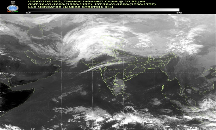
Northern India is grappling with a fresh and active western disturbance, triggering widespread snowfall in the Himalayas and rain and thunderstorms in the plains, according to the India Meteorological Department (IMD). The weather system, active through January 28, 2026, has prompted alerts for multiple states, disrupted transport and posed risks to residents and travellers alike.
Intense Snowfall Forecast for Hill States
The western disturbance North India weather system will continue to bring light to moderate precipitation across the high-altitude regions of Jammu and Kashmir, Ladakh, Himachal Pradesh and Uttarakhand, the IMD said. Isolated heavy snowfall, rain, thunderstorms and strong winds are expected in several mountainous districts on January 27 and 28.
These conditions raise the threat of avalanches, landslides and roadblocks in vulnerable zones. Dense fog has also reduced visibility in isolated pockets across parts of Himachal Pradesh and Uttarakhand.
Also Read : Delhi Braces for Light Rain and Gusty Winds; AQI to Improve Temporarily on January 27–28
In Himachal Pradesh, major road closures and power disruptions have been reported. More than 1,250 roads remain shut, hampering transport and isolating remote villages. Tourist hotspots like Shimla, Manali and Kufri remain crowded with visitors enjoying the snow despite difficult conditions.
Authorities in Uttarakhand have raised avalanche alerts for high-altitude districts following forecasts from the Snow and Avalanche Study Establishment (SASE). Rescue teams and emergency operations centres are on high alert to respond to any weather-related emergencies.
Impact on Plains: Rain and Storm Alerts
The effects of the western disturbance North India system have extended into the plains. Parts of Punjab, Haryana, Chandigarh and the Delhi-NCR region are forecast to experience light to moderate rainfall, thunderstorms, lightning and gusty winds on Tuesday.
In the National Capital Region, the IMD has issued a yellow alert, warning residents of rain, thunder and strong winds throughout the day. Gusts could reach 30–40 km/h or higher at times, intensifying the winter chill even as temperatures shift.
The disturbance has also led to cold wave conditions in isolated pockets of northwestern states, including Haryana and Punjab. Dense to very dense fog has been reported in parts of Uttar Pradesh and Uttarakhand, further complicating travel and daily outdoor activity.
Weather Hazards and Safety Alerts
Meteorologists have highlighted the possibility of isolated hailstorm activity over parts of Jammu and Kashmir, Himachal Pradesh, Uttarakhand, and western Uttar Pradesh. Thunderstorms accompanied by lightning remain likely across several northern and central Indian states.
Dense fog advisories are in place for morning and night hours in many regions. Residents have been urged to limit non-essential travel, maintain safe distances on roads and stay updated with local weather alerts.
Forecast Beyond January 28
While the current western disturbance is expected to ease after January 28, another fresh western disturbance may affect northwest India from the night of January 30, bringing yet another round of rain and snowfall. Temperatures in the plains may see a temporary rise in minimums by 3–5°C, followed by fluctuations as the weather pattern evolves.
Note: This article integrates the latest verified weather updates to ensure accuracy and timeliness. All forecasts and alerts are based on official sources including the India Meteorological Department. Readers are advices to check the current update before venturing out.